Category:Garibaldi Volcanic Belt
Jump to navigation
Jump to search
volcanic chain in British Columbia, Canada  | |||||
| Upload media | |||||
| Instance of | |||||
|---|---|---|---|---|---|
| Location | British Columbia, Canada | ||||
| Mountain range | |||||
| Highest point |
| ||||
| Elevation above sea level |
| ||||
 | |||||
Subcategories
This category has the following 13 subcategories, out of 13 total.
+
- Maps of Garibaldi Volcanic Belt (11 F)
B
C
- Castle Towers Mountain (7 F)
- Clinker Peak (7 F)
G
M
P
- Mount Price (25 F)
S
T
- The Table (16 F)
- The Barrier (8 F)
Media in category "Garibaldi Volcanic Belt"
The following 11 files are in this category, out of 11 total.
-
 Canadian Cascade Arc.png 544 × 466; 45 KB
-
 Eruptive history of the Mount Meager Volcanic Complex.png 671 × 527; 23 KB
-
 Franklin Glacier Volcano.jpg 450 × 500; 48 KB
-
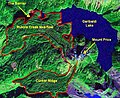 Garibaldi Lake area map.jpg 574 × 468; 81 KB
-
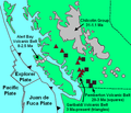
 Garibaldi Volcanic Belt-en.svg 2,200 × 1,700; 1.9 MB
-
 Garibaldi Volcanic Belt-fr.svg 2,200 × 1,700; 1.9 MB
-
 Mount Meager tectonics.png 470 × 575; 362 KB
-
 Salal Glacier volcano.jpg 1,110 × 718; 612 KB
-
 Slag Hill and Ring Mountain.jpg 400 × 255; 51 KB
-
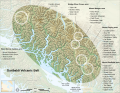
 Squamish volcanic field.png 360 × 546; 312 KB
-
 Watts Point and Howe Sound.jpg 639 × 476; 55 KB


Categories:
- Volcanic belts in Canada
- Volcanic belts
- Subduction volcanoes in Canada
- Volcanic belts in British Columbia
- Pleistocene volcanism of British Columbia
- Holocene volcanism of British Columbia
- Pleistocene magmatism of British Columbia
- Holocene magmatism of British Columbia
- Canadian Cascade Arc
- Quaternary volcanism of British Columbia
- Places named after Giuseppe Garibaldi